AIS Vessel Tracking
Bristol Maps can display AIS (Automatic Identification System) vessel positions on the navigation page, giving you real-time awareness of nearby vessel traffic.
What is AIS?
AIS is a maritime tracking system used on ships and by vessel traffic services. AIS transponders broadcast vessel information including:
- Position (latitude/longitude)
- Speed and heading
- Vessel name and MMSI number
- Vessel type and dimensions
Bristol Maps receives AIS data and displays it as targets on your map.
Enabling AIS
AIS vessel targets can be enabled from the navigation settings. When enabled, nearby vessels broadcasting AIS will appear on the map as labeled icons showing their name, speed, and heading.
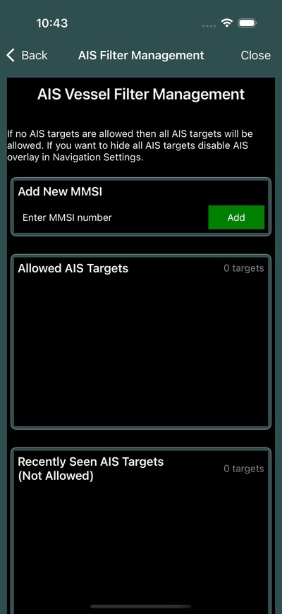
AIS Filter
The AIS filter allows you to control which vessels are displayed:
- Open the AIS filter from the navigation settings
- Add specific MMSI numbers to an allowed list
- Only vessels matching your filter will be displayed
This helps reduce clutter on the map by showing only the vessels you care about, such as your fleet members or specific tenders.
Tip
If you have an MMSI number for a specific vessel you want to track, add it to your filter list to see only that vessel's position.
AIS via NMEA
If you have an AIS receiver connected via NMEA, Bristol Maps can display AIS targets from your local hardware in addition to cloud-based AIS data.
The AIS Sharing toggle in NMEA Settings allows you to share AIS data received from your local hardware with your fleet group.
AIS Target Display
AIS targets appear on the map with:
- Vessel name label
- Speed indicator
- Heading direction
- Position updated in real-time
Related
- NMEA & GPS Setup -- Connect an AIS receiver via NMEA
- Map Overview -- AIS targets on the navigation page
- Groups & Sharing -- Fleet location sharing